
1
/
of
1
Rand McNally
Rand McNally Easy to Read Folded Map: Montana/Wyoming State Map
Rand McNally Easy to Read Folded Map: Montana/Wyoming State Map
Regular price
$7.99 USD
Regular price
$7.99 USD
Sale price
$7.99 USD
Unit price
/
per
Shipping calculated at checkout.
642 in stock
Couldn't load pickup availability
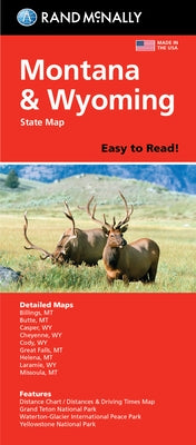
Rand McNally's Easy To Read State Folded Map is a must-have for anyone traveling in and around Montana and Wyoming, offering unbeatable accuracy and reliability at a great price. Our trusted cartography shows all Interstate, U.S., state, and county highways, along with clearly indicated parks, points of interest, airports, county boundaries, and streets. The easy-to-use legend and detailed index make for quick and easy location of destinations. You'll see why Rand McNally folded maps have been the trusted standard for years. -Regularly updated, full-color maps. -48% larger map with a bigger type size than the Rand McNally Folded Map. -Clearly labeled Interstate, U.S., state, and county highways. -Indications of parks, points of interest, airports, county boundaries, and more. -Mileage and driving times map. -Detailed index. -Convenient folded size. Coverage Area: Detailed maps of Billings, MT; Butte, MT; Casper, WY; Cheyenne, WY; Great Falls, MT; Helena, MT; Missoula, MT; Waterton-Glacier International Peace Park, Yellowstone/Grand Teton National Parks. Product Details: Dimensions (unfolded): 28 x 40.
Author: Rand McNally
Publisher: Rand McNally
Published: 08/06/2021
Binding Type: Folded
Weight: 0.10lbs
Size: 9.40h x 4.00w x 0.30d
ISBN: 9780528024566
Author: Rand McNally
Publisher: Rand McNally
Published: 08/06/2021
Binding Type: Folded
Weight: 0.10lbs
Size: 9.40h x 4.00w x 0.30d
ISBN: 9780528024566
Not available to be shipped via Media Mail
Share
No reviews